Polymap 3.1.0
PolyMap is a desktop mapping program to create thematic maps.
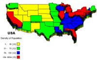
PolyMap is a desktop mapping program that lets you use your own data to customize the maps supplied with the program. The Map Presentation Wizard gives you a step-by-step process to customize your map and the maps legend.
Software Specs
Publisher:............ Ambiente Informatica Ltda
License:............... Shareware
Price:................... $89.95
Expire: ................ 30
File size:.............. 7.37 MB
Downloads:.........
Release date:...... 05 Sep 2010
Last update:........ 23 Sep 2012
Language:............ English, German, Italian, Portuguese, Spanish
Publisher review for Polymap 3.1.0:
Review by: Ambiente Informatica Ltda
PolyMap is a desktop mapping program that lets you use your own data to customize the maps supplied with the program. Use the built-in spreadsheet to enter data or paste it from other Windows applications. Alternatively, you can use the import feature to bring in data from external spreadsheets, text, or database files. The Map Presentation Wizard gives you a step-by-step process to customize your map and the map's legend. Any data in a spreadsheet column may be utilized for labeling. You may use a set of geographic layers in different formats (state and county boundaries, five-digit ZIP codes, U.S. and state highways, cities, rivers, and lakes) to add details and create your new thematic map. For instance, state and county boundaries can be "extruded" to 3D prisms, shaded in color, "sprayed" with a dot-density distribution, embedded with individual pie and bar charts, or placed into a matrix for portfolio analysis. New custom point layer can be added to the maps. Maps and spreadsheets may be printed with any Windows-compatible printer.
Maps can be exported to Bitmap format (.bmp) enhanced Metafile (.emf) PNG (.png) JPEG (.jpg) and Adobe Acrobat (.pdf). PolyMap send JPG Bitmaps of the maps as attachment, to any e-mail address using MAPI compatible e-mail clients like Outlook Express or Mozilla Thunderbird.
This trial version will function for only 30 days and comes with only a fraction of the maps available in the registered edition. Additional sample maps, WiKi documentation and a tutorial are available from the PolyMap Website.
New Functions: Charting Module, Export to PDF format, Consolidate Data, Radius select, Map to Web link, Geocoding
Requirements:
Pentium Celeron, 256 MB Ram
Operating system:
Win2000,Win7 x32,WinServer,WinVista,WinXP
Release notes:
Major Update
Whats new in version 3.1.0:
Add Points from Latitude and Longitude by Geocoding, OpenSteet Map

Polymap screenshots:
Polymap download tags:
Map Maps Mapa Mapas Mapping Landkarte Karte desktop mapping GIS thematic maps informative maps presentation business maps spreadsheet
Copyright information:
Based on 1 ratings. 1 user reviews.